With MPR Every Step of The Way
Aug 11, 2017
MPR Supporter Bob Johnson dedicated his 2017 hike to MPR in honor of the organization's 50th Anniversary.

With MPR Every Step of The Way
Bob Johnson, MPR Member
We Are MPR even when we're miles away! MPR Supporter Bob Johnson dedicated his 2017 hike to MPR in honor of our 50th Anniversary. Enjoy this recap of his travels on the Pacific Crest Trail.
Introduction
By Bob Johnson
With a desire to help promote awareness and support of the great programming generated every day by Minnesota Public Radio, I will be sharing my hiking team's journey during August through October, on an 800-mile section of the Pacific Crest Trail in the Sierra Nevada mountains of northern California. We'll journal photos and text here so that you can follow us on this adventure.
Stretching from the Mexican border to the Canadian border, the Trail is a national treasure that winds its way 2,660 miles through national parks, wilderness areas and private lands. On its journey, it climbs mountains, descends deep valleys and fords countless streams and rivers. Referred by the equestrian and hiking community as "the PCT," it is classified as a wilderness endurance trail.
While the Trail has existed for decades, not many people know about it. It became better known after the success of Cheryl Strayed's memoir, "Wild" and the movie inspired by her book. Cheryl solo hiked 1,100 miles of the Trail in 1995. A one-season PCT thru-hike (the entire length of the Trail) involves 5.5 months of continual motion by foot, often on an established path, sometimes on hard rock scramble. Thru-hikers need to average 17 miles a day to finish before snow closes the mountain passes. In 2016, only 11% of those who started managed to finish. Although anyone who is in reasonably good shape can make the hike - after all, it's just a matter of putting one foot in front of the other 6,650,000 times - it's still not for the faint of heart. The southern section in the California high desert, where most hikers begin, can be challenging. During the day it's blistering hot and you must carefully plan your water sources. At night it's freezing. You are hiking for 12 to 14 hours every day and sleeping on the ground every night. You are constantly exhausted, hungry and dirty. And, then there are rattlesnakes.
My hiking team will initially consist of four women: Miriam Buckman, Paula Tillett, Stephanie Wallisch, Jamie Ziemann, and myself. We will step onto the PCT on August 14 at the Tuolumne Meadows trail head in the northern section of Yosemite National Park. All of the women will exit the trail after completing the first 50 miles. Then, two men (Brian Kelly and Mark Estlund), one from Minnesota and one from Nebraska, will join me for the next 65 miles, to Truckee, California. From there, I plan to continue on to Ashland, Oregon with a trail partner from Monterrey, Mexico.

We've spent the past six months buying and testing gear, planning menus and food drops, climbing flights of stairs to strengthen our legs and practicing skills such as: How to operate cans of bear spray if confronted by one of those on the trail. And, I completed a three-day medical first responder course offered by the National Outdoor Leadership School (NOLS). As our departure day approaches, we've finalized our equipment selections, arranged ground transportation where needed, and our two trail bosses, Becky Johnson and Diana Jurand, are busy in the office packing the resupply boxes that they will mail to select drop points on the Trail ahead of us.
We are excited about our hike. Everyone is ready to go! And we are proud that MPR will share updates from our journey. I will be on the Trail for up to nine weeks. There will be good times and there will be some not-so-good times. Hopefully, the bears and cougars will stay away. Cell phone service will be largely non-existent in the mountains, so I will send updates whenever a tower is close enough to provide email service. Whatever does come our way, we all invite you to "hike along" as we experience the Trail.
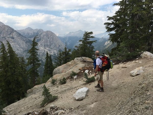
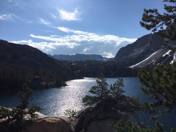
Photos: First week on the trail
Bob Johnson & company ready for the Pacific Crest Trail

The Pacific Crest Trail sign at Tuolumne Meadows

A MPR50 hat keeps Jamie Ziemann warm in the cool morning air

The MPR50 bandana along for the journey

The team finds their own pace while traveling together

Bob Johnson takes in the view
Beautiful Barney Lake on the Pacific Crest Trail

Snow in August is to be expected at high altitudes

A trek past Peeler Lake wrapped up the first week
Diary: First week on the trail
August 14, Monday: Day one of the MPR hike of the PCT
Stephanie and I flew to Reno on Saturday the 12th to take care of arrangements for a van we needed for the drive to Bridgeport, CA - our jumping off point for the trail. At 4:00am, Stephanie received a call from Paula and Jamie at the Minneapolis airport saying there was an issue with how the tickets were booked and the airline was not going to issue them boarding passes. After a somewhat frantic hour, Paula and Jamie convince the airline staff to let them board and made the flight to Reno. Our hiking permits were limited to one specific day for pick up, and had Jamie and Paula missed that flight we were all out of luck.
After all members of our hiking party arrived in Reno (including Miriam on a separate inbound flight from Washington), we drove our rented van to Bridgeport where we had reservations at The Ruby Inn, dubbed "The gem of the Sierras." After offloading our gear at the inn, we walked one block to a nearby restaurant for drinks, dinner, and conversation. We met a hiker who just finished a section of trail we are hiking, and gained some helpful intel on trail conditions, mosquito activity, and water crossings.
The next morning we stopped at a sporting goods store to buy fuel containers, bug nets and a few other odds and ends needed for the hike, then drove to Tuolumne Meadows in Yosemite National Park. At the ranger station, we picked up our hiking permits and certified that we are carrying bear vaults to lock up food. The saying out here is, "A fed bear is a dead bear." And, we don't want any of that. A local driver dropped us off at the PCT trailhead in Tuolumne Meadows, and will park our rental van 50 miles north to have it available to us when we get off the trail at a public campground on Friday afternoon.
This first day on the trail was filled with excitement and anticipation. Unfortunately, two forest fires nearby obscured some of the mountain views and the smell of smoke was fairly heavy in the air. We enjoyed the scenery just the same and made multiple picture stops in the first 5 miles from Tuolumne Meadows to Glen Aulin campground--the halfway point of today's hike. One picture stop led to our first casualty of the hike, as one of my hiking poles accidentally rolled off a bridge and plunged over a waterfall. When we arrive at Glen Aulin, we find the bridge to the campground washed away as a result of the torrential waters coming down stream from the record snowmelt. In spite of that we were able to climb over the wreckage to get into the campground where we could set down our packs, take a break and make some lunch.
We hike another six miles to a meadow and camp among pine trees with a small creek 50 yards away. We are all carrying heavy backpacks. In spite of the difficult miles we hiked today, none of us are very hungry. We ate lightly, set up our tents, and cleaned up with water from the little creek nearby. We need lots of calories to hike, as we are burning 450 to 750 calories per hour, but our appetites are small. Some of us are feeling a bit dehydrated. The 8 to 10% humidity dries us out at this altitude very quickly. As a result, we need to drink much more water than normal. We are all in our tents this first night by 7:30pm. We are five very tired hikers who are not acclimated to the high-altitude. We hiked 11 miles today and have another 11 miles to hike tomorrow.
August 15, Tuesday
The day begins at 6:15 a.m. as we awake to blue skies and clear air. The smoke is gone! There was an extremely heavy dew last night and everything is totally soaked. Clothes that we hung on nearby pine trees to dry are so wet we can ring water out of them. We empty our tents and set them up facing the sun to dry. It takes us 90 minutes to break camp, which is a long time compared to most hikers, yet none of us are anxious to pack up all this wet gear. Finally, it is time to get going and we head down the trail, which begins at an altitude of 8,620 feet above sea level.
Today is marked by spectacular views. Every time we round a corner, crossing a ridge, we come to views that are beyond description. Offsetting the beautiful views are the incredibly difficult climbs. It's not just heavy backpacks, it is the fact that we arrived from Minnesota and have asked our bodies to adjust from 700 feet above sea level to nearly 2 miles above sea level. The atmospheric pressure is only 30% of what it is in Minnesota and we are all breathing hard, sweating profusely and struggling step-by-step up steep mountain trails. It seems that whenever we look at the trail it is headed up hill. Of course, that's not true. It goes downhill as much as it goes up yet it seems to always be up. The climbs consist of setting short goals that are achieved with burning leg muscles. One looks at the trail, finds a spot 50 or hundred yards uphill, and then through sheer will power gets to that spot. After that achievement, we stand and pant until our heart rates slow down enough to do it again. Five or 600 of those make up the day.
At 5:30 p.m. we start down a long mile and a half descent of 2,200 feet into the second valley for our overnight camp. When we arrive at our selected campsite we find a fairly large group of tourists on a horseback trip. They're sitting around a large campfire having steak, salad and wine. We make chicken and dumplings in an aluminum pouch that we stir and let sit for 20 minutes before eating. While we're enjoying dinner, several of their horses decide to wander over to see us and are especially interested in our bear vaults that contain all our food. Apparently they can smell it even though it's locked up. Ten minutes later one of the wranglers comes over and herds them back to a pasture. Just before total darkness, we hear a bell ringing as a white horse leads 10 of the horses to pasture north of us a quarter-mile. I'm pretty sure I heard a cougar call in the distance, so I tell the women to not wander too far from camp in the middle of the night.
August 16, Wednesday
Wednesday dawns bright and chilly. It's 6:00 a.m. and we're all sleeping in hoping for some warm sunlight to warm us before we start packing up. Paula's knees are really bothering her. The mountain descents are killers for knees and we're going to have to take it slow and easy today as we watch how she does. That's fine with me because my legs are almost nonexistent. Her downhill pace will average out with my slow uphill pace so that we will all be in camp at just about the same time. I heat some water for mixing an instant breakfast of scrambled eggs and hashbrowns. It sounds horrible, yet is actually pretty good especially with a few gourmet spices brought from home. We pack up to start another 10 mile day, which includes a long uphill over a ridge that takes us down to Benson Lake. It's a beautiful lake with mountains on three sides and a large sandy beach. If we can make it, will have a great overnight campsite and be in a good position for the next day.
As things turn out, Paula's left knee is swollen and sore and she, Miriam and Jamie are not able to make it all the way down the mountain before dark. Under Jamie's guidance, the three women pitch tents on the trail and sleep in a small clearing next to a stream, a quarter-mile short of Benson Lake. Stephanie and I made it to Benson Lake, and set up camp in the dark using headlamps. After our tents were in place, we walked back to search for the others, during which we saw bright eyes reflecting at us in the woods. Stephanie thought that they were probably cougars or bears looking at us. After crossing an ice-cold stream in the dark to find them safe, we all agreed that we would meet at Benson Lake in the morning.
August 17, Thursday
Jamie, Miriam and Paula joined me and Stephanie at Benson Lake around 8:00 a.m. We took some extra time to dry out clothes and tents, and enjoy the views we couldn't see in the dark last night. Just before 10:00 a.m., I took off up the trail to get a head start, knowing that we had another challenging 10 mile hike up and over our third mountain pass. Just when you feel like you can't go any further, the beauty of the surroundings propels us forward. At mile 976, we exit the Pacific Crest Trail and head northeast on a separate trail that will eventually lead us to Twin Lakes campground. The trail levels out a bit as we meander through meadows alongside gorgeous clear water streams. Miriam and I are about 15 minutes behind the rest of the group, and at 6:30 p.m., we decide to make camp early enough to avoid setting up in the dark again. The mosquitoes are especially thick as the sun sets, and chase us into the safety of our tents. We assume the others are camped about a quarter mile further down the trail, based on the arrows and notes written in the dirt on the trail.
August 18, Friday
Today we hike 9 miles to Twin Lakes campground, where we'll be rewarded with homemade burgers, and a ride to a hotel. The low lying areas of the trail are saturated which require us to creatively navigate flooded areas and stream crossings. A mix of emotions hit as we pass the Yosemite National Park exit sign - sad to leave but excited to be able to get rid of the heavy bear vault! We pass Peeler and Barney lakes along the way, and they literally look like a picture you'd see on a postcard. Once past their rocky shorelines and numerous downhill switchbacks, we see many more day hikers indicating we are close to our destination. After arriving at the campground, our burger dreams come true and we drive our van 90 minutes to Minden, Nevada where the next hiking adventure will begin with Mark and Brian.
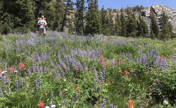
Photos: Second week on the trail
Bob's new team takes to the trail

Stream crossings are common and tricky

A stunning sunset

Look closely and you'll see the trail along the ridge

Wildflowers in bloom
Diary: Second week on the trail
August 19, Saturday
We did some gear swapping last night so that Mark and Brian would have all the proper equipment for the trail. At 8:00 a.m., Jamie, Paula, Miriam, and Stephanie headed to the Reno airport to fly home. We guys hired a local taxi for a drive to the trailhead at Echo Lake Chalet. It turns out that hiking along Echo Lake on the PCT is a very popular activity, especially on weekends. The trail was crowded with day hikers out with their kids, dogs, and grandmas and grandpas. It looked as though everyone who could reach the lake was on the trail. After the first 5 miles, however, the crowd thinned out and the trail traffic returned to more normal levels.
Several hours and 1,000 feet of elevation later, we reached the boundary of the Desolation Wilderness and Aloha Lake - a spectacular body of water that only photographs can adequately describe. Along its shorelines, weekend campers had pitched their tents. We passed them by with a friendly hello. In return, most wished us a great hike.
Even though the morning preparations prevented us from getting to the PCT trailhead of Echo Lake until past 12:30 p.m., the three of us hiked and covered 9.4 miles before darkness forced us to find campsites. To our surprise, we made it to the north shore of beautiful Susie Lake. Arriving there close to sunset, we found that the few existing campsites were already taken. That forced us to search for some flat parcels of ground that would accommodate our tents. It was getting dark, and we hurried to find some piece of ground flat enough to hold a tent. As I hustled down the mountainside to the east shore of the lake, the shoelaces of my left foot caught the tip of a small dead pine tree lying beside the trail. Usually, I can just pull my feet free from any little thing that catches them on the trail. This tree decided to hook itself to my shoelaces and not let go. So, when it was time to swing that foot forward to support the next step, I found it trying to pull a 50-pound tree trunk with it. Oops - here comes a fall and too late to get a hiking pole out front to stop it! Where and how do you want to hit the ground, Bob? How about that forest duff next to the rocks instead of on them? OK! Here comes the impact. Get your right arm and shoulder around and try to take the hit on your backpack. Umph! That hurts. Anything broken? No? That's good. Those 1,000 skydiving jumps and parachute landing falls just paid off. Nothing worse than a sore shoulder. Now, the next challenge is figuring out how to get up off the ground lying face downhill at a 30-degree angle with a 35-pound pack on top of me and pushing my face into the dirt. Lying there laughing out loud at my own fallibility doesn't help, yet it makes it all a little easier. In actuality, the whole event is over and I'm back up and on my feet in 39 seconds. There are places to go and things to do. The scraped knees and twisted shoulder can be attended to later. At least Brian and Mark were some distance behind me and didn't see the stumble. It would have been embarrassing if they had.
Toward the end of the day, Brian and Mark find tent sites in amongst some very tall pine trees. I find a small previously cleared tent site further down trail near the inevitable stream and make camp there. We agree to meet at 7:00 a.m. for a group breakfast. We would like to camp together, yet sometimes it just happens that we end up in dispersed locations. Once it begins to get dark, you sometimes need to take whatever you can find. As the sun was lowering behind the mountain across the lake, I still had time to make a dinner of homemade gourmet chili with pasta. Wonderful! It is difficult to describe how good simple food can taste at the end of 6-1/2 hours of hiking.
Brian says that he is exhausted. Mark hiked so hard that he feels ill and skips having supper, choosing to just head right for his sleeping bag. Later, I will tell them that they made it barely as far as the ladies did the day before.
My last action of the day is to tie my nylon bear-proof sack to a nearby tree. After that, it is 8:30 and lights out to sleep. A nice reality of endurance hiking is that you are so exhausted when you lie down that it takes only moments to fall asleep. I am out by the count of 10. However, at 1:00 a.m., I wake up long enough to poke my head outside of my tent to enjoy the beauty of the night sky.
August 20, Sunday
The day begins with the sound of something walking past my tent. A bear!? Nope. Another hiker. He is going to climb a small nearby hill to have his breakfast while he watches the sunrise. I am close enough to the trail to say good morning out the open "door" of my tent as he passes by. It's a young male hiker from Japan. He is wearing a down ski jacket with a scarf wrapped around his face to stay warm in the cold mountain air. That indicates a cold morning, yet, at our camp altitude of 8,000 feet, it feels a relatively balmy 35 degrees this morning!
Outside of the spectacular views and eating fresh snow at 9,300 feet as we prepared to hike over Dicks Pass, the most interesting part of the day was a hailstorm at 5:00 p.m. We saw rain clouds moving our way and when they arrived they delivered hail in sizes anywhere from an eighth of an inch to a half-inch. Large enough to hurt. We took shelter under pine trees for about 45 minutes and when the storm abated we made the decision to set up camp where we were instead of trying to press ahead for another hour and having to be pitching our tents in the dark with headlamps.
Every day, we are sending SPOT location messages by satellite back to our trail bosses in St. Paul. The message that they receive is a link to a Google Earth photo with our location marked on it. They get to follow our progress with location accuracy of 30 feet. If we have an emergency, we can press the SOS button on the device and a helicopter shows up 90 minutes later. Good peace of mind for our families back home.
We send the SPOT message at 9:00 p.m. and call it a day. Tomorrow, we are going to try to find time to swim in one of the snow fed lakes. We view the possibility as a once in a lifetime opportunity (thank goodness).
August 21, Monday
Monday on the trail with Brian and Mark had us camping overnight from the day before at about 8,700 feet above sea level. Because of the rain and hail storm the day before, everything in our camp, including us and our gear, was very wet. It took an amazing two hours and 45 minutes for us intrepid hikers to get up, make breakfast, clean up in a nearby brook, break camp and step onto the trail. We need to do better than that. We need to be up and out in an hour and 15 minutes.
Today is the eclipse. We are looking forward to seeing it from the top of a mountain ridge somewhere along the PCT. Mark has a piece of dark glass from a welder's helmet so we can watch the eclipse directly. We watch the moon moving across the upper portion of the sun and the brightness of the trail becomes more faint.
There are flowers everywhere today. It must be spring at this altitude. We met a number of other thru hikers, as opposed to day hikers up for the weekend. Two are a young couple in their early 20's who are hiking the Tahoe Rim trail and claim to be averaging 27 miles a day. We shake our heads in disbelief at that. It's not that we disbelieve they can accomplish 27 miles in one 10-hour day, it is that we could never do it. We share some of our food and snacks with them, after which they rapidly disappear up the trail as if hiking uphill or hiking on flat ground were one and the same to them.
By evening, we have achieved our 9-1/4 miles for the day and get into our anticipated campsite on the shore of a small mountain lake. The water is clear and warm. We take a swim to get clean. It's nice to get in a campsite early enough in the evening to build a fire and have a chance to relax before everything turns black with the moonless night.
August 22, Tuesday
At 10 o'clock last evening, it appeared as though someone was firing old fashion flashbulbs over the tops of the trees to the east of our campsite. When the heavy thunder reached us we realized a thunderstorm was on its way. For the next hour, lightning crackled overhead and the exploding thunder echoed off of the mountainsides all around us. The thunder would rumble down the valley and back again after every bright flash. Altogether, a magnificent display of positive and negative electrons seeking each other out in the sky. Then, the rain started. Fortunately, we had elected to pitch our tents on higher ground on the off chance it might rain. That decision probably saved at least one of us from having a flooded tent. At midnight, everything calmed down and we got a solid 5-1/2 hours of asleep.
From a mileage point of view, the hike today was the easiest of the week so far. It began with a vertical climb of nearly 2,000 feet. However, unlike some other sections it gave us a relatively gentle incline. The trail was often dirt or duff as opposed to hard rock. We traveled a short 8.57 miles, stopping for a half hour lunch at the top of Barker mountain pass. At 4:00 p.m., we decided to stop early in consideration of the threatening storms all around us and the fact that we came across a great campsite at 8,000 feet elevation that offered more than adequate space for all three of us plus a view down the valley to the east overlooking Lake Tahoe. Mark built a fire in a fire ring overlooking the valley and that's where we had dinner. The words that I possess simply cannot describe the beauty of the evening as we watched the setting sun fall down the valley walls. (Lest you think that we suffer too much, we had lasagna with meat sauce as our main course followed by creme brulee for dessert.) It doesn't get much nicer than this!
We retire at 8:00 p.m., hiker midnight, with the expectation of seeing a memorable sunrise in the morning.
August 23, Wednesday
Considering that the endurance hiker is living 24-7 on the trail to exposed conditions, it's not surprising that the first question every morning is, "how's the weather?" Every hiker wants to know what sort of environmental conditions she or he is going to be hiking in that day. The weather impacts all sorts of decisions ranging from how much water do we carry if it's hot to where are we going to camp so that our tents don't get flooded out by rain running down the mountain.
Our fifth day on the trail began with a bright sunrise and then blue skies with an occasional white cloud floating overhead. The temperatures were in the lower 60s and the humidity was probably in the range of 7 to 8%. In other words, a perfect day for hiking - no worries about weather today.
I may have mentioned that it seems as if every day starts with an uphill climb. Considering that most campsites are situated near water sources, which generally are streams or brooks in mountain valleys, perhaps it is true that every day begins with an uphill climb. Ours today began with hiking up and over and around the backside of Squaw Valley ski area. We started uphill at 8:28 a.m. and huffed and puffed continually in that vertical direction, with heavy packs on our backs until 1:15 p.m., all without a single break other than to find our water bottles for a drink.
It's high and dry out here and we are sweating profusely as we burn 500 - 700 calories per hour. Our hiking speed on a vertical uphill climb drops from an average of 2.5 miles an hour on level trail to something closer to 0.5 mph on the uphill. The compensation and gratification for all of this difficult physical activity are the magnificent views. Every time we round the saddle of a hill or climb up over the crest of the ridge we are rewarded with awe inspiring vistas. The common phrase seems to be that you've got to endure the pain to get the view.
We are meeting far fewer people than we did the first two days of our hike. Now we might see one, possibly two, thru hikers headed southbound from Canada on their way to the southern PCT terminal at Campo, California near the Mexican border.
August 24-25, Thursday & Friday
Mark, Brian and I came down out of Donner Pass on Thursday evening, a half day earlier than planned. The campsite we had expected to use Thursday evening was small and dry with no water nearby. Seeing it, we decided to press on and make the last 6 miles down the mountain to the highway where we could get some cell phone service and call a taxi from Truckee. Our total mileage for the day was 16.5, much more than our daily average. Our total "up and down" for our six-day hike was about 11,000 feet each way. Two and a half miles up and down along with 61 miles of trail.
After overnighting at a hotel, we met the next afternoon with Diego Gomez who flew from Monterrey, Mexico to join me for leg three of my MPR hike. Potentially, he and I will be sharing the trail all the way to Ashland, Oregon. We are total strangers and it will be interesting to see if we hike in sync or not. Time will tell.
August 26, Saturday
Saturday morning, Brian and Mark departed for home, and Diego and I hired a cab to take us 10 miles west of Truckee to the PCT trailhead. We put our feet on the trail at 8:45 a.m. and to our mutual surprise, clicked out 14.98 miles for the day, a total that included some substantial vertical climbs. Checking the trail app in my iPhone, I see that we climbed over 2,450 feet along with descents of more than 2,660 feet. It looks as though we went down a little more than we went up, however the downs are easy while the ups are grueling.
At 6:00 p.m. we made it to our intended campsite by a little creek that barely had water flowing. It gave us enough water for a meal of gourmet chili with ramen noodles for Diego and chicken with noodles for me. We are now relaxing by a safe campfire not near any tree roots or pine duff. Diego brought along a ukulele and plays some evening music by the fire. How does it get any better than this?
Q&A with Bob Johnson
When did you decide to take up long-distance hiking as a hobby?
My office is in the Wells Fargo Building in downtown St Paul. I have a view of the State House. Looking out of the window one February day in 2015, and feeling slightly bored, I wondered which challenge would be more enjoyable: running for state office or climbing a mountain trail. The trail won. I spent the next five months researching a long-distance, endurance hike on the Pacific Crest Trail. I read "Wild" by Cheryl Strayed and saw "the movie" of her 1,100 mile hike of the PCT in 1995. I read books about wilderness hiking that covered everything from map reading to first aid. I watched dozens of YouTube videos by other thru-hikers. I called and spoke to other hikers, some of them as old as me, who had completed the entire six-month thru-hike of the 2,660 mile Trail from the Mexican border to Canada.
Not having the luxury of leaving work for six months, I opted for hiking the state of Oregon, from north to south (the "wrong" way) during September and October of 2015. That hike consisted of 354 miles of mountain trail hiking with about 154,000 feet of vertical ascent/descent. Last year, I was able to squeeze in a two week hike of 125 miles on a section of the Trail south of Lake Tahoe. This year the goal is a hike of 776 miles from a starting point in north Yosemite National Park and an ending point of Ashland, Oregon. If all goes as planned, it will take nine weeks of steady hiking and involve six friends who will join up for different parts of the trek. Two "trail boss" ladies back in our office in St Paul will be providing logistical support and mailing food supply boxes to various points along the trail. When hiking, we try to be in, or near, a town or post office about once a week for resupply - and a shower, if we are lucky.
This year's hike begins August 13 from Tuolumne Meadows in Yosemite National Park. Three friends from St Paul, and my trail partner from 2015, Miriam Buckman, a 28-year old hiker from Israel, will be joining together for the first week. Then, the ladies return to Minnesota and two male friends, one from Saint Paul and one from Omaha, fly out to Reno to meet up and hike to Truckee, CA. After that, they all leave the Trail and a young fellow, Diego Gomez, a chef from Monterrey Mexico, will be joining me for the next seven-week leg.
Preparation for a hike such as this - a long distance endurance hike on a wilderness trail - can be a challenge in and of itself. My wife does not like the idea of me hiking alone, or without conditioning, so I've made a special effort to keeping her happy by doing the following three things: I took a multi-day, first responder wilderness first aid course sponsored by NOLS, the National Outdoor Leadership School. Then, Trish and I went to the scenic mountains of Ouray, Colorado, where I hiked in higher elevations with a backpack every day for a month. Finally, I located other hikers to team up with so that I could avoid hiking solo. As a result, Trish is happier and I am better prepared. (Always listen to your wife!) While I am hiking this summer, Trish will be vacationing in France with gardening friends. While I'm eating camp food and sleeping on the ground, she will be drinking good wine and sleeping in a soft bed. During my preparatory research, I found that many hikers endure the physical and mental hardships of this sort of hike in connection with promoting a good cause. Since Trish and I consider MPR an important asset in our regional and national life, I hope that sharing this hike with folks may help increase their interest in supporting MPR.
Letter from the homedesk: Meet Trish Johnson
Bob mentions his wife Trish often. She is a fan of MPR in her own right, and she shared her perspective with us.

"I think of public radio as a series of mini college courses. I learn about science, medicine, economics, literature, politics, theater, local issues, and so much more every day. Topics that on my own I might never explore. I am enjoying the lectures from the Aspen Ideas Festival enormously. I also look forward to the Commonwealth Club and Westminster Town Hall Forum speakers. MPR is my source for education, every day I learn something new by listening to MPR." - Trish Johnson
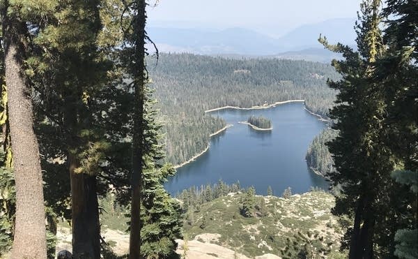
Photos: Third week on the trail
A mountain lake

Music is a companion around the campfire

Normally clear valley air is filled with smoke

Diary: Third week on the trail
August 27, Sunday
Crunch. Crunch. Crunch. Crunch.
The cadence of your hike is reflected in the sounds of your shoes crunching gravel or pine needles. It's a steady rhythm all day long. Other than the whistling whisper of the wind through the evergreen trees, the one constant sound is the crunching of footsteps on the trail. Except in a high alpine meadow that's in full bloom. There, if you stand quietly and listen for a minute, you will hear the entire meadow humming with the buzz of honeybees. In the warm sun, it's difficult to avoid succumbing to the temptation to just while away the entire morning looking at the scenery and listening to the wildlife.
Diego is turning out to be an interesting chap. Seems that he's not only a pretty good chef, he has hiked in Spain and on numerous other trails, and thus has legs of iron. He can out hike me by nine minutes every hour. In addition, he's a reader and has brought hardcover books along to enjoy in the evenings. And, he plays the guitar and ukulele. Last night, he was strumming and singing John Denver songs. In the morning before we hit the trail, it appears that he likes to spend 15 minutes practicing yoga, or at least a quiet meditation to prepare for the day. Altogether, he's a pretty good intellectual who enjoys the out-of-doors and the physical challenge of hiking an endurance wilderness trail such as the PCT.
Tomorrow, we start our day with a 450-foot vertical climb and then waltz down the trail into Sierra City, one of our resupply points. Most likely, we will overnight in that little town prior to tackling the 3,700-foot vertical climb out of it to the north the next morning. Diego is out hiking me by a wide margin. Today, he hiked 5.25 miles in 90 minutes. The same stretch took me 2.5 hours.
August 28, Monday
Our morning begins at 4:30 a.m. We are trying to make an early start to conquer the two mountaintops ahead of us during the cool morning hours. We cover the first 6.5 miles in 3.5 hours and then meet at Milton Creek for lunch. The creek is really a fast-flowing mountain stream with clear, cold snowmelt water. It feels good to take off our shoes and boots and soak our hot feet in that icy cold water. Lunch wraps up and we head 5.5 miles into Sierra City where we will attempt to find a motel room to overnight, clean up and resupply.
Supplies are turning out to be a bit of a conundrum in that we are eating a third less than anticipated. I have already bounced a supply box ahead from Truckee to Belden, and the next resupply point up the trail we will likely need to do the same with a portion of the extra food we are going to be receiving at Sierra City. Additionally, I need to arrange transportation to the top of the mountain going north. Neither one of us likes the idea of making a 3,700 foot climb first thing tomorrow morning.
It's 4:00 p.m. We road hike on hot asphalt 2 miles in 94d temperatures to the town's general store where, hopefully, our resupply boxes will be found. After drinking a large milkshake and two cans of cold root beer, I dig around in the hiker box room and locate one box for Diego and two for me. I can tell from the weight that much of this food is going back to Saint Paul.
The most important thing to do, now that we have our resupply boxes, is locate a place to stay overnight. It's too late to try to hike to a campground, and way too hot in any event. The population of Sierra City is 254. Despite being small, there are three different places to stay and we score two nice cabins at a locally-owned resort. The owner, Lulu, even offers the use of her laundry facilities so that we can start off tomorrow with clean clothes. We are going to take hot showers, sort out our food supplies to see what goes to the post office in the morning, and then walk five minutes down the street to a local steakhouse for dinner. Along with all of this, and with the help of the general store manager, I scored the hire of a driver with a jeep to take us to the top of the mountain north of us. Some local coin will be exchanged in return for the ride and we could not be happier about that.
August 29, Tuesday
Here are some of the observations that marked this day:
The bakery in Sierra City is open only Thursday, Friday and Saturday. So, if on a Tuesday morning, you're looking for a Danish pastry with a hot cuppa coffee at the bakery, you're not going to find it there.
The general store is where all the information about what's happening in town goes to and through. Larry, who seems to have been running the place forever, knows everyone and everything. If there's anything at all you want to know about what's happening in Sierra City, you can learn it from Larry. Incidentally, he makes some of the best deli sandwiches I've ever tasted. Diego and I each picked up a sandwich in the morning to have for lunch. Mine was so large that I ate half for lunch on a mountaintop and the other half for dinner in a high alpine meadow.
If you see a deer while hiking the PCT, stand very still and whistle gently. The deer will often stop to look at you and, in some cases, even walk over to investigate what sort of animal is making those strange bird sounds.
It's never too early to get into camp, set up your tent and get your gear arranged.
No matter how ice cold the stream by your camp might happen to be, it's worth the shock of the cold water to take a field shower to remove the dirt.
From the high mountain ridges that we hiked over, we could see a large forest fire, or at least the rising plume of smoke from it, nearly 50 miles to the west. It appeared that the smoke plume was topping 50,000 feet. Something very big is on fire over there.
There are half a dozen milk cows, all of them wearing very large and loud Switzerland types of bells around their necks, wandering around our campsite. It's like we are on the movie set of Sound of Music, or something. Julie Andrews is expected to show up any moment now. We're hoping they settle down and don't keep clinking and clanking around all night long. Right now, as I look out the door of my tent in the last little bit of daylight, I can see 20 of them standing 10 feet away, all in a line looking at us. I think that we pitched our tents in their evening pasture and they are confused about what to do next. I shouted out at them and after a moment they turned and followed the leader, a big black Holstein, down the hill. We could hear their bells ringing all the way down to the lower pasture.
August 30th, Wednesday
This was a day of tough vertical climbs with very little water along the way. I have been hiking, often slowly, in pain all day. I believe I must have pulled a back muscle when I took that tumble last week because I am experiencing a sharp pain in the muscle under my right shoulder blade. It's been there every day for the past five days and doesn't seem to want to take care of itself. I need to find out how many Aleve it's safe to take in one day. I am at three in 10 hours right now. Otherwise, this is going to be a very difficult hike because I need to stop every 200 yards to try to lift my pack and relieve that painful muscle.
It's 7:00 p.m. and we are set up for the night in a small campsite about 29 miles north of Sierra City at mile marker 1,226 on the trail. We are anticipating darkness in about an hour. Yet, here comes a southbound thru hiker stopping for water as he tries to catch his buddy who's a mile or two ahead of him. He scooped a bottle of water out of a little pothole by our tents. And, by pothole I mean a little water seep from a marshy spot on the side of this ravine that is no larger than a cooking pot. The water he pulled out was filled with sediment and slightly less brown than a cup of coffee. I offered to filter it for him, however he said that he was used to drinking sediment and didn't think a little bit of dirt in his water would hurt him. My and Diego's backpack each weigh in the mid to upper 30 pounds fully loaded with water and food. This hiker said that his total backpack weight was about 11 pounds without water and that he never carried more than two or three pounds of that. So, his total pack weight is running less than half of ours. We made 12.8 miles today. He is hoping for 27. Pack weight is one reason why he can do that. At the same time, he said that he sometimes just slept on the ground under his rain poncho rather than taking the time to find a campsite and set up his tent and other gear. That's an approach we are not willing to take. So, the trade-off is extra weight and fewer miles.
A nice highlight of the day was sitting on a log right by the trail, filtering water when a young spike buck walked by to get a drink and stood looking at us from 15 feet away, totally unafraid. His antlers were still covered with heavy velvet and he acted like seeing hikers was not a big deal for him. We watched the deer for a minute or two, and when I stood up to get my backpack, he decided to scamper off into the brush.
August 31, Thursday
The three topics for today are water, old trees and forest fires.
Water is an especially precious commodity on a hike such as this. That's particularly true now that we are north of the Sierras. Those mountains had record snowpack last winter and all of the creeks and streams were flowing with cold, clean mountain snowmelt water. The lakes were full and there was water everywhere. Now, we are north of there and everything has turned noticeably drier. Some water sources listed in our PCT trail phone app are totally dry. Careful planning for water is important no matter which part of the trail you're on. That being said, heading north from our current location (approximately 40 miles north of Truckee, California) requires that we plan our water resources very carefully because we do not have the snowmelt here as we did behind us in the Sierras. For example, tomorrow we have an 8 mile stretch between listed water sources and we're hoping that when we get to the water source, a mountain spring, that it is flowing. If it isn't, we will need to hike with little or no water for another 5 miles to the next listed source. On this section of the PCT, until one gets to the state of Washington, water is constantly on our minds.
We are collecting water wherever we can, sometimes in a little puddle in brooks that would normally be flowing earlier in the year. Tonight, we are dry camping. That means that there are no water sources within a reasonable distance and, consequently, we were forced to lug about 8 pounds of water the last 3 to 4 miles. Now, 8 pounds of water doesn't sound like much. Yet, when you add it to your backpack weight at the end of a long day, one where we climbed over the top of two 7,000 feet high mountains, that's a ton of extra weight. Just before getting to this campsite, there was a 350-foot hill to negotiate and I wasn't sure I could physically make it to the top.
Trees constantly blow down across the trail and volunteer trail crews come out to clear most of them, God bless them. What happens with the big ones is that a section of the log (approximately 6-feet wide) is cut out of the tree trunk to open the trail. I stopped to count the rings of one freshly cut blow down and tallied more than 280 rings. Where was America 280 years ago? That would've been approximately the year of 1737. It seems a bit too early for Benjamin Franklin to have been spending time in France. In any event, it was a grand old tree that has stood there nearly 3 centuries.
Forest fires. The forest floor is covered with downed, dried timber. The whole place is a tinderbox. When we began our hike this morning, and got up to a high point on the first of two 7,000 feet high mountains, we could see a large fire had just started burning about 30 miles to the west of us. The smoke plume expanded rapidly into the upper atmosphere. Heavy smoke filled the valleys ahead of us. Within two hours somebody had it under control and largely snuffed out. Everything in these mountains and hills is extremely dry and ready to burn.
Most of our trail tomorrow will be downhill. The next two days after that are going to be leg killers. We have one mountain alone that will involve more than 2,800 feet of vertical incline. And then, there are more after that. Fun!
September 1, Friday
Today was our second highest mileage day at 13.5 miles. Our mileage number might've been greater except for the fact that we descended about 2,200 feet down into a river valley to cross the East Fork of the Feather River. This evening, after logging 10 trail miles, we climbed 850 feet back up the north side of the gorge. Tomorrow is going to be an especially challenging and difficult day. Right out of tent we face a climb of 2,700 feet to complete the exit from the Feather River gorge. I'm not sure that I can climb 2,700 feet all in one stretch, with a heavy backpack. So, we're just going to see how it goes. If we have to make it a one-and-a-half-day hike to the top of the mountain, then that's what it will be.
During the last couple of days, we have passed 10 to 15 hikers headed in the opposite direction. Those who stop for a minute or two of conversation tell us that a substantial number of hikers this year stopped their hike somewhere in the Sierras due to the heavy snow pack, and they jumped (or in the parlance of the trail, flipped) up to Canada and started south with the expectation of finishing the skipped Sierra section southbound.
From our start tomorrow we have 34 miles left to Belden and we should be able to complete that in about 3-1/4 days.
Photos: Fourth week on the trail
Forest fires throughout the west affected hikes and more

Beautiful views never grow old

Bob hikes the ridgeline step by step

Evidence of past burns in our present trip

Pines so dense you can almost smell the picture
A colorful thermal pool - best enjoyed at a distance

Diary: Fourth week on the trail
September 3, Sunday
This was one of the best days of my hike so far. We had great prime rib last night, a good night's sleep and accepted a ride 4 miles to the PCT trailhead. We were on the Trail by 9:30am, and for some reason, my legs today felt like I had expected them to feel the first day, strong and ready to hike. Thus, the 1,650 foot climb we faced first thing in the morning turned out to be not nearly the struggle that other climbs had been. In fact, it was an enjoyable walk up a tall hill!
For today, we decided to make camp about 9 miles short of town. That allowed us to find a campsite by 4:00 p.m. instead of when it is beginning to get dark. We made a fire and, not long after that, an optometrist from Southern California came strolling down the trail. He set up his tent across the creek from our campsite, 50 yards away, and brought his cooking equipment and food over to our campsite for dinner and socializing. Right now, Diego is entertaining us with songs and music on his ukulele. I'm not always quite sure what it is he is singing, yet it's cheerful and enjoyable just the same. All that we are missing is a good red wine or, perhaps, a nice Brandy to sip after dinner by the fire.
Getting into a campsite early also allows us to get hiker showers in the nearby stream. The water here, at lower altitude is a bit warmer than it was in the High Sierras where the water is all snow melt. It was cold, yet totally refreshing. It is truly wonderful to be able to pour fresh, clean water over yourself, from head to toe, so that you can lie down feeling clean and comfortable as opposed to dirty and sweat grimy.
Tomorrow we will overnight Monday and maybe Tuesday in Belden to resupply, wash clothes, and catch up on things. Ahead of us is a 7-day leg to Burney Falls.
September 4, Monday
We start later start this morning. We look out over the hills and valleys and see that visibility is reduced to a mile or two. Everything is hidden behind a screen of forest fire smoke. We're beginning to be able to smell it, like a faint, distant campfire.
We have a 5,000-foot descent into Belden. That's about three hours of downhill walking. It will be interesting to see how the knees like that exercise.
As we descend, the smoke thickens and visibility drops to 1/2 mile. I find that I have some cell phone service halfway down and receive an email from home with a link to a newspaper story about hikers being stranded by fires in Oregon. Apparently, search and rescue up there is dropping food and water to hikers who are trapped. About 140 of them. Later, in town, we speak to several hikers who have friends in that group. One of them tells us that the PCT is completely closed north of Etna, California. If that's true, then our hike is going to end early at that point.
We have some decisions to make ourselves right now. Do we try to hike north out of town and endure a 5,000 foot climb out of the river valley in all this smoke? Or, do we attempt to hitch a ride north? We go for option number two and, as luck would have it, discover that one of the waitresses at the restaurant where we are having lunch lives a half hour north of Belden and will give us a ride to Chester, California where we can overnight and regroup. We load our backpacks into her small car and leave for Chester in 97 degree temps. Her car's air conditioning is broken and she drives with only one hand on the wheel as she takes the 35 mph curves at 50-60 mph. Yet, despite the exciting ride, we arrive safely and overnight at the Best Western, directly across the street from the best malt shop within 50 miles.
Four days ago, I bit something hard and broke the crown off an upper tooth. So, as soon as possible in the morning, I am off to find a dentist to see what can be done about that. Several boxes of food have arrived and we will be sorting out all of that and then looking for a trail angel ride 6 miles west to the PCT to continue our on-foot adventure northbound.
September 6, Wednesday
A very interesting day of hiking. The terrain was not particularly scenic. We spent most of the day walking through mature forest and the tall pine trees hid the long views from us. On the other hand, we hiked past a lime green volcanic lake in the Lassen Volcanic National Park and could see the steam rising from the hot, bubbling surface. I have seen other lakes and ponds like that in Yellowstone National Park, yet this was the first time Diego had ever seen something like this. He was quite impressed. He asked what would happen if someone fell into it.
9.5 miles from our starting point, we came across the Drakesbad Guest Ranch, a rustic resort hidden away in the upper mountain valleys of Northern California. Once again, our luck held true and we rented the last two cabin rooms available on the property. The cabins are rustic, which means that while the plumbing is modernized and up-to-date, there is no electricity in the rooms.
We enjoyed a buffet barbecue dinner on the deck of the restaurant building. It was obvious which guests were hikers and which were tourists. Other hikers joined us. One was a young fellow from Sweden who is hiking the entire 2,660 miles from north to south. When we asked him why he said that he woke up in Sweden one morning and felt that he was in mood for a long walk. Another southbound hiker was a young woman whose trail name is Hummingbird. She is small in stature, is an ultra-marathon runner, and is covering 30 to 35 miles per day on the PCT. That means she hikes in one day what Diego and I do in three. Her father recently passed away and she felt that a long hike was a good way for her to get her emotions and thoughts in order.
Hikers eat a lot. "Hiker hunger" kicked in about day 10 for me. We all had it at dinner. My meal included the following:
A half bottle of beer
A third bottle of Vouvrey
One hamburger
One very large bratwurst
Cole slaw
Portobello mushrooms
Three ears of sweet corn on the cob
A slab of BBQ spare ribs
A slice of prime rib
Six chocolate chip cookies
Two large brownies
Five cups of coffee
And, I was STILL hungry! We are burning about 4,500 calories per day and the body wants to replace those. On the trail, it's nearly impossible to carry enough food to meet your body's caloric demands. The weight of the food exceeds your ability to carry it up the mountains. So, it's sort of a real feast or famine situation.
The mental side of endurance hiking: Most of the thru hikers whom we've been meeting on the trail are college graduates in their middle 20's to 30's. Scattered among the trail population are folks in their 60's and 70's, people who are beginning to approach middle-age and who are on the trail for exercise and adventure. While many are hiking the trail for the same reasons we are -- because it's a national treasure and a beautiful place to be -- others are making a special effort to get away from whatever they've been dealing with at home. A long 5-1/2 month hike, or even a long section hike, gives many people an opportunity to leave the pressures or routines of their everyday lives and travel to a place where they can reduce the demands on them down to the most basic terms. Hiking endurance trails such as the PCT quickly teaches one to focus on simple tasks such as: where do I find my next water supply or where do I plan to camp before dark. One learns to understand what is essential for enjoying each day and what is not. It's surprising to come to realize just how little we actually need. Since, as a hiker, you need to carry on your back absolutely everything that you need to exist, all of the excess baggage quickly goes away. The psychological aspects of endurance hiking are just as interesting and demanding as the physical. For some, the long trail produces boredom. For others, it produces a sense of freedom that cannot be found in the routine of everyday living.
September 7, Thursday
20 miles today! Even though we had a late 9:40 a.m. start, we cracked out 20 miles for the day. That's a new record for me and the highest mileage day so far of this entire hike. I attribute that to the massive intake of calories at the barbecue last night. My legs felt like they could walk all night. And that despite two larger climbs first thing in the morning. Our vertical up today was 1,777 feet and our down was 2,630 feet. Down is always easier. Regrettably, we don't get to go down until we climb up.
There were many interesting people on the trail today including a group of three from Sweden. Earlier in the afternoon, I met a thirty-something fellow from Germany and at least two other people who, saying hello and I hope you're having a nice hike as they passed by, had foreign accents. Just like Minnesota Public Radio, the trail is a national treasure and people from all over the world come here to enjoy it.
We are camping this evening at mile 1,367. Our tent sites are next to a fast-flowing, cascading stream with clear, cold water that we can easily access. We got into camp at 6:30 p.m., later than we would prefer. That left us just an hour and 15 minutes to collect water, cook dinner and set up our campsite. The stream banks are rather steep and the water is flowing fast. Falling in would probably be fatal. We searched for and found a path established by other hikers that led down to a relatively flat spot on the rocky river bank of the stream where I rinsed today's trail dirt out of my clothes and washed myself from head to foot. It's surprising how dirty one can get in just a nine-hour day of hiking.
Today was long, tomorrow will be relatively short. It appears that we have just 6 miles to hike to a place named Old Station. Resupply boxes should be there, along with replacement tent poles for me. And Debbie, the manager of the general store, said that if we were around at 5:00 p.m. when she closed the store, she would give us a ride up the trail to Burney State Park. That's important because the alternative is a 35 mile stretch around something called Hat Creek Rim. That's a volcanic depression in this volcanic part of Northern California. It is a 35 mile stretch with no water. It's cooler out here today. The high temperature for most of the trail today was probably in the middle 60's. Around Hat Creek Rim, with the sun reflecting off the volcanic rock and no shade, the temperatures can easily exceed 100 degrees. What they'll be like tomorrow we do not know, but we accept her offer of the ride 20 minutes to Burney State Park to avoid that Hat Creek Rim section.
Just before finishing these notes in the dark on Thursday evening, three 30-something male hikers heading south rolled into camp with their headlights on. They have set up their tarp tents and are sitting together with their headlamps illuminating their cooking equipment while they make supper. I looked at one of their tent set-ups - a tarp over a line stretched between two hiking poles. It appears that the hiker laid his sleeping bag directly on the dirt, without a mattress or sleeping pad or ground cover under him. When hikers do that, and get to the point where they're looking grimy, they are referred to as hiker trash. That, of course, is not any sort of statement about their personality or character, only about their physical appearance. Some of them haven't seen a shower for several weeks. Hopefully, they take advantage of the stream for a hiker's shower in the morning. Otherwise, they're not going to be overly welcome at the next restaurant or grocery store at which they stop.
September 8, Friday
Yesterday, we hiked to a California town named Old Station. It's a gas station/store, restaurant and the Rim Rock Ranch Resort fishing cabins. Our resupply boxes were supposed to be waiting for us at the store. Digging through the "back room" where all of the hikers' supply boxes were kept, next to the auto tires and other gas station equipment, we quickly realized that they were not there. The store manager, a friendly fellow in a blue gas station shirt, said that FedEx was due to make another delivery about 3:00 p.m., and if we wanted to relax by one of the picnic tables in back, we could wait to see what showed up.
While we did that, several southbound hikers arrived from up the trail. All of them had stories to tell about the forest fires burning ahead of us. One couple said they had begun their southbound hike on the Canadian border on July 4th and that this, September 8, was the first day that they had seen the sun. Another young hiker, a 23-year old fellow hiking solo, said: "It's a total disaster up there," as he pointed back over his shoulder with his thumb.
I said to Diego: "We've got some executive decisions to make. There are fires burning on four sides of us. The trail is closed north of Etna, our next stop. Everything smells likes it's been burned. If we start hiking now, the odds are pretty good that we'll just have to turn around and come back. I believe we should call it a hike and exit the trail while we're someplace where a car can pick us up."
He agreed.
So, our hike ended in Old Station, slightly more than half way to our initial goal. We gave our food supplies to passing hikers heading south and called our hike done. It snowed here this evening, and last week it was 102 degrees in the same location - a good example of weather extremes in the mountains!

I started at PCT mile 942 and ended at mile 1,374. That's 432 trail miles. After deducting a section skipped (hiked last year) and a couple of car/truck rides to trailheads, the net miles hiked totaled 307. That's 614,000 steps, ascents of 44,555 feet and descents of 52,505 feet. That's 8.4 miles up and 9.9 miles down.
Altogether, a very nice walk!